My Pan-American Cycling Route is Beginning to Unfold!

My second favorite thing about bicycle tour planning (only after ogling photos of beautiful locations and idyllic campsites), has begun: Actually sitting down, creating a list of where I want to go and putting it on a map. Today, I’m taking a look at making my dream Pan-American route a bit more of a reality.
Now, I’ll stop right there and insert this get to know me tidbit: I love lists. I make lists of everything – groceries, bike parts, to-dos, to-sees, gear I need, things I know, things I don’t, and on and on. I write them on my computer, on my phone (it’s a lucky day when I actually sync the two), on napkins and teeny tiny pieces of scrap paper. And then, I have lists on lists and lists about lists and everything feels a little chaotic.
So, I sit down and organize.
But planning a bicycle touring trip that spans a couple continents and even more countries is extra intimidating. So, I’ve put it off any formal route building until now.
Partially because I wasn’t sure if I was actually going to do it. Partially because I really wanted to embark with a group of people. And partially because, I was at a friend’s house a while back and they have one of those murals of a world map that takes up their whole wall from floor to ceiling – and it was huge. As I stood there, dwarfed by North and South America, my legs already started hurting from the idea of pedaling all those miles.
But it’s time to face my fears and keep in mind that plans may change and I may not cycle the whole route, but I’ve got to start somewhere.
The Longest Road in the World
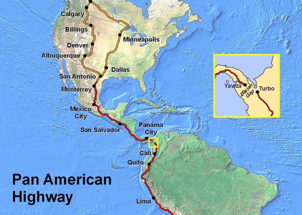
I’ll loosely be following the Pan-American Highway through North, Central and South America. The idea is that it’s the northern-most point in North America – Prudhoe Bay – to the southern-most point in South America – Ushuaia. I know I’ll have to start in early summer, and that the date may change because of weather and snow that far North.
So far, I’m mapping out pillars of places I really want to go and seeing if the pins on the map loosely follow some semblance of a route.
The Darien Gap
The two questions people usually ask is how I’m going to get around water and what I’ll do about the Darien Gap. I’m no superhero, so I’ll have to do what everyone else does and take a boat or plane. This is literally a no-man’s land. It seems like, if the land, weather or animals don’t kill you here, the people will.
Definitely best to go around…
Mileage
And for those of you who have ever thought or asked me, “how many miles is it from Prudhoe Bay, Alaska to Tierra del Fuego, Argentina?”
I sometimes tell people it’s around 11,000 miles.
But did a haphazard search on the interwebs and discovered it’s more than 11,000. A lot more. In fact, the Pan-American Highway itself spans 19,000 miles (30,000 kilometers). Excuse me while I go have a minor panic attack.


Ah, yes. The Darien Gap. When I do my round the world bicycle trip, there will be an unwritten rule to fly only where there’s no reasonable alternative. I hope to even do ocean crossings by boat, ship, or some other water transport (probably not by kayak, though!). So, to get from Panana to Colombia, I’ll try and do it by boat.
I’ve definitely heard of a lot of people going that route. I personally had the same philosophy as you (about only flying as a last resort), but I seem to have mentally given that up a bit as I’ve read stories and anecdotes from other travelers. I want to prioritize the journey, my safety, and the overall experience over being able to say that I biked every inch (though that is certainly a badass claim I do hope to have). I’ve pushed on during some smaller rides and really regretted the toll it took on my body. Ultimately, I want to know that the option is there for myself (with no self-judgment), but hope I don’t necessarily want to take it!